Home / Destinations / Heritage / Natural /
Sinharaja Rain Forest
Last updated on 02 May 2023Show location
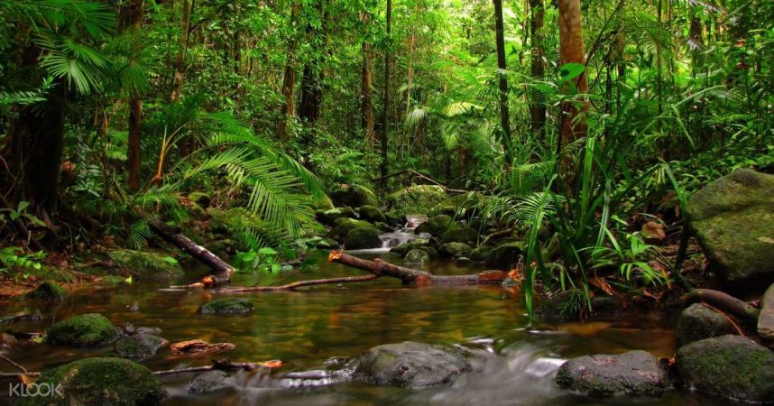
The World Heritage Sinharaja Wilderness, a place with the highest biodiversity, located in a cold environment at 3000 feet above sea level, is known as an upland ecosystem.
Primarily for educational purposes, university students and institutes and research related to plants are given permission subject to the approval of the head office and only 30 species of plants, flowers and birds native to Sri Lanka can be easily seen from this place in the section reserved for tourists. You can go through Rathnapura, Kiriella, Kalawana, and Weddala to get to Sinharaja Forest Reserve from the country's north or west. Deniya is the southern gateway to the Sinharaja Rain Forest. You can access Sinharaja from the Rawana side if you're coming from Hambantota, Udawalawa. The Sinharaja mountain range, a group of hills in the southwest of the island, is the second-largest in Sri Lanka. At its lowest point, the woodland is 270 meters above sea level. Hinipitigala, the tallest mountain, is 1171 meters high. The eastern slopes of this mountain range, in Suriyakanda, sometimes referred to as Sinha raja’s "Morning Side," are where tea and pepper are farmed. Sinharaja is a really lovely and alluring location. The last surviving portion of Sri Lanka's tropical lowland rainforest, the 18900-acre Sinharaja Rain Forest (a UNESCO World Heritage Site), is situated in the Sabaragamuwa and Southern provinces in the country's south-west lowland wet zone. Rivers encircle Sinharaja on three sides. Sinha raja’s northern border is formed by the Koskulana Ganga and Napola Dola. The rivers Maha Dola and Gin Ganga are located on the south and south-west. The rivers Kalukandawa Ela and Kudawa Ganga are to the west. A historic walk can be found to the east of Sinharaja, by the Denuwa Kanda and the Beverley Tea Estate. The Moulawella Peak and the Sinha gala Peak are reached by taking the two main nature routes of the Sinharaja Rain Forest. Both of these nature walks, which start at Kudawa Conservation Centre (KCC), are interesting and enjoyable. While there are many towering trees growing close together in the forest, the trekking is made easier by the curving trails. The trails are cut through by tiny streams of cool, clear water that are home to numerous fish, toads, and crabs. Also, a variety of bird species can be spotted in the forest's canopy. Moreover, Sinharaja is a Man and Biosphere Forest Reserve, and a significant amount of the forest's vegetation is indigenous to the nation. There are some species that are unique to the Sinharaja Forest. There are numerous endemic animal species in Sinharaja. Sinharaja serves as a habitat for a variety of animals because it is a rainforest with a rich and complicated array of vegetation. Animals eat plants, but they also perform other tasks that are necessary for some plants to thrive. Two of these are seed spread and pollination. Both monsoons are beneficial for Sinharaja. Except for February, when it's dry, rain occurs frequently during the southwest monsoons, May through July, the north-east monsoon, and November through January.

Since this forest was designated as a World Heritage site in 1988, numerous endemic species of flora and animals have been found there, demonstrating the significance of Sinharaja as a natural World Heritage site. Several herpetofauna species that are confined (or "point endemic species") to the eastern area of Sinharaja are among the most recent discoveries. These conclusions are the result of thorough study that has been done in Sinharaja over the past three decades with careful planning. The location is a national symbol for preserving biodiversity in Sri Lanka, which has helped raise public consciousness of conservation issues significantly. However, existing conservation issues such as encroachment of forest due to agricultural expansion (e.g., tea plantations), human dwellings, unsustainable tourism developments, fragmentation due to road construction, spread of invasive species and illegal collection of rare and endemic species for international trade, could seriously compromise the conservation of the World Heritage site in the future. The local populace, which is spread out across a number of villages along the border, is well integrated with the reserve. While there are fewer villages along the northern border due to the presence of some big estates, there are more villages along the southern border. The residents have a plethora of resources at their disposal, including a plethora of information on the internet, as well as a variety of books, magazines, and websites. The sap is transformed into jaggery, vinegar, and a regional brew. While they are not engaged in their other agricultural endeavors, locals take walks in the forest to gather the aforementioned products. Also, the majority of the population living in the reserve's surrounding area gets their water from the pristine streams that dot the landscape. Locals have made the annual pilgrimage to the Adams Peak by hiking through the forest from south to north for generations.